File:Tilemaps bw.jpg
Jump to navigation
Jump to search
No higher resolution available.
Tilemaps_bw.jpg (639 × 105 pixels, file size: 13 KB, MIME type: image/jpeg)
Summary[edit]
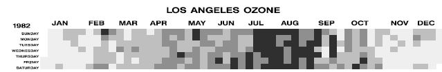
tilemap (greyscale) showing ozone-concentration in LA
Copyright status[edit]
Source[edit]
[Mintz et al., 1997] Mintz, D., Fitz-Simons, T., and Wayland, M.. Tracking Air Quality Trends with SAS/GRAPH. In Proceedings of the 22nd Annual SAS User Group International Conference (SUGI97), pages 807–812, 1997. PDF
File history
Click on a date/time to view the file as it appeared at that time.
| Date/Time | Thumbnail | Dimensions | User | Comment | |
|---|---|---|---|---|---|
| current | 14:33, 27 November 2006 | 639 × 105 (13 KB) | UE-InfoVis0607 9926534 (talk | contribs) | tilemap (greyscale) showing ozone-concentration in LA |
You cannot overwrite this file.
File usage
The following page uses this file: